


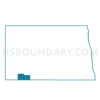
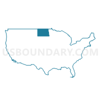
Adams 39-01 Voting District, Adams County, North Dakota
About
Outline

Summary
| Unique Area Identifier | 641907 |
| Name | Adams 39-01 Voting District |
| County | Adams County |
| State | North Dakota |
| Area (square miles) | 287.81 |
| Land Area (square miles) | 287.53 |
| Water Area (square miles) | 0.28 |
| % of Land Area | 99.90 |
| % of Water Area | 0.10 |
| Latitude of the Internal Point | 46.07160850 |
| Longtitude of the Internal Point | -102.16262800 |
Maps

Graphs
Select a template below for downloading or customizing gragh for Adams 39-01 Voting District, Adams County, North Dakota


Neighbors
Neighoring Voting District (by Name) Neighboring Voting District on the Map
- Adams 39-02 Voting District, Adams County, ND
- Grant 31-04 Voting District, Grant County, ND
- Hettinger 31-01 Voting District, Hettinger County, ND
- Sioux 31-07 Voting District, Sioux County, ND
- VTD - Lemmon ward 1 (part of precinct 1), Perkins County, SD
- VTD-precinct 3, Perkins County, SD
- VTD-precinct 4, Perkins County, SD
- VTD-precinct 5, Perkins County, SD
- VTD-precinct Morristown, Corson County, SD
Top 10 Neighboring County Subdivision (by Population) Neighboring County Subdivision on the Map
- Lemmon city, Perkins County, SD (1,227)
- West Grant UT, Grant County, ND (343)
- Lincoln township, Perkins County, SD (164)
- East Adams UT, Adams County, ND (161)
- Lemmon UT, Corson County, SD (57)
- Clermont township, Adams County, ND (35)
- Menz township, Sioux County, ND (28)
- Baer township, Hettinger County, ND (26)
- Orange township, Adams County, ND (22)
- Beisigl township, Adams County, ND (22)
Top 10 Neighboring Place (by Population) Neighboring Place on the Map
Top 10 Neighboring Unified School District (by Population) Neighboring Unified School District on the Map
- Lemmon School District 52-4, SD (2,124)
- Hettinger Public School District 13, ND (2,071)
- Mott-Regent Public School District 1, ND (1,550)
- Elgin-New Leipzig Public School District 49, ND (1,371)
- Selfridge Public School District 8, ND (396)
Top 10 Neighboring State Legislative District Lower Chamber (by Population) Neighboring State Legislative District Lower Chamber on the Map
- State House District 31, ND (13,907)
- State House District 39, ND (13,645)
- State House District 28B, SD (9,885)
Top 10 Neighboring State Legislative District Upper Chamber (by Population) Neighboring State Legislative District Upper Chamber on the Map
- State Senate District 28, SD (19,903)
- State Senate District 31, ND (13,907)
- State Senate District 39, ND (13,645)
Top 10 Neighboring 111th Congressional District (by Population) Neighboring 111th Congressional District on the Map
Top 10 Neighboring Census Tract (by Population) Neighboring Census Tract on the Map
- Census Tract 9683, Perkins County, SD (2,982)
- Census Tract 9659, Grant County, ND (2,394)
- Census Tract 9656, Adams County, ND (2,343)
- Census Tract 9410, Corson County, SD (1,744)
- Census Tract 9408, Sioux County, ND (1,575)
- Census Tract 9647, Hettinger County, ND (1,134)